The Inland Waters Thematic Data Products (TDP) are taking into account the improvements made in the frame of the REAPER project and the ENVISAT reprocessing 3.0. The Inland Waters TDP proposes products containing Water Surface Height associated with a dedicated flag . An uncertainty value is computed for each measurement.
Data Access
Data can be downloaded here.
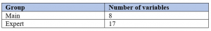
NetCDF groups
There are two NetCDF groups (main and expert)
Processing & Algorithms
- Surface type based on GLWD3
- Occurence of water based on GSWE (Global Surface Water Explorer)
- Quality flag using the neural network classification
- Range coming from Ice-1 retracker
Improvements compared to existing products
For the hydrological community, one of the main advantages is the availability of a product dedicated exclusively to inland waters for users who are not necessarily altimetry experts. It includes a quality flag of the measurement as well as the associated uncertainty. Additionally, the product contains external and useful information concerning the type of surface based on GLWD3 (Global Lakes and Wetlands Database) as well as the occurrence of water during the 1984-2015 period, based on GSWE (Global Surface Water Explorer).
Moreover, thanks to the use of NetCDF format and its characteristics, particularly the use of groups, the information for expert altimetry users is also available. This information includes the different components used in the estimation of the water height such as the geographic corrections, the range from the existing retrackers or the waveform classification.
Quality flag for the whole ENVISAT mission